← Back
Water Level Easing
Easing — down from 0.16 at 10:15, now 0.12
0.12

Enfield, Ordance Road

Small River Lee
Lower Lee catchment • Sewardstone • Greater London • ID: 5339TH • Level
(36m ago) • 4 readings/hr • 126 views

Set water level alerts

Get notified about Enfield, Ordance Road — tick as many as you like, they all share the notify settings below.

⤴ Unusual rise — FloodRadar+Top 1% rise rate for this gauge.
Drag the line on the chart, or type a value: m
Quick pick:

Each one is saved as its own alert — pause or remove them individually any time.

Not an emergency service — if in danger call 999. Alerts rely on EA/SEPA/NRW data and are best-efforts. Terms

Current Level
0.124 m?
▼ Easing
24h Max
0.160 m
24h Min
0.124 m
Typical Range
0.11 - 1.40
m
Past 12 months 0.06 – 0.36 m
Highest Recorded
1.17 m
30 Oct 2000
Since Jan 1982
Current level is 11% of this
🚽 Sewage overflows nearby

Recent Water Levels

🌍 floodradar.co.uk
1 day

Recent Readings

Falling · -4 cm over 5h
22 Nov 15:15 ▬ steady 0.124 m
22 Nov 15:00 ▼ -0.1 cm 0.124 m
22 Nov 14:45 ▼ -0.1 cm 0.125 m
22 Nov 14:30 ▼ -0.1 cm 0.126 m
22 Nov 14:15 ▬ steady 0.127 m
22 Nov 14:00 ▼ -0.1 cm 0.127 m
22 Nov 13:45 ▼ -0.1 cm 0.128 m
22 Nov 13:30 ▼ -0.2 cm 0.129 m
22 Nov 13:15 ▼ -0.1 cm 0.131 m
22 Nov 13:00 ▼ -0.1 cm 0.132 m
22 Nov 12:45 ▼ -0.3 cm 0.133 m
22 Nov 12:30 ▼ -0.1 cm 0.136 m
22 Nov 12:15 ▼ -0.3 cm 0.137 m
22 Nov 12:00 ▼ -0.3 cm 0.140 m
22 Nov 11:45 ▼ -0.4 cm 0.143 m
22 Nov 11:30 ▼ -0.3 cm 0.147 m
22 Nov 11:15 ▼ -0.4 cm 0.150 m
22 Nov 11:00 ▼ -0.3 cm 0.154 m
22 Nov 10:45 ▼ -0.2 cm 0.157 m
22 Nov 10:30 0.159 m

Station Details

  • Monitoring Station: Enfield, Ordance Road
  • Watercourse: Small River Lee
  • Nearest Town: Sewardstone
  • County: Greater London
  • Coordinates: 51°40'19"N 0°1'11"W (51.671889, -0.019618)
  • Open in: Google Maps · Apple Maps (opens your maps app)
  • Date Opened: 1 Jan 1981
  • Status: Active
  • Station Type: River level station
Technical details: references, datum, range, flow archive
  • Station Reference: 5339TH
  • RLOI id: 7365 (the EA's check-for-flooding station id)
  • EA Gauge ID: 5339TH-level-stage-i-15_min-mASD
  • Parameter: Level
  • Unit: m?
  • Typical rise rate: 4 cm/hr (p95 sustained over 90 days)
  • Typical data delay: ~22 min (measured reading→publication lag)
  • Tidal: No
  • Distance to the sea: about 19 km by river (estimated along OS Open Rivers)
  • Lock / structure: No
  • Catchment Area: Lower Lee
  • Typical Range: 0.108 – 1.400 m
  • Drainage Area: 42 km² upstream of this gauge
  • Flow Data: Daily mean flow (m³/s) to 19 Nov (3 days behind — the EA publishes each day's mean a day or two after it ends; unchecked, provisional) via EA Hydrology
  • EA Cross-check: 0.12 m (EA at 22 Nov 15:15)
  • Flow Archive: National River Flow Archive ↗

Geographic coordinates may reflect the access point for the gauge, and not the precise location in the watercourse that it is taking readings from.

Nearby Stations

Gauges connected to this river, and others nearby. A distance “by river” follows the river on the map; any other is in a straight line.

Connected upstream

Connected downstream

Same river system, separate branch

Nearby

Distances by river: OS Open Rivers. Contains OS data © Crown copyright and database rights 2026.

💧 Storm overflows upstream of this gauge

None of the storm overflows FloodRadar holds is traced upstream of this gauge on the mapped river network. That is not the same as none: the map leaves out many small streams and culverts, so an overflow it cannot place may still drain here, and not every company publishes every overflow. Those nearby are listed below.

Nearby, connection not known

Within 6 km in a straight line, but the river map cannot say whether their water passes this gauge.

💧
Thames Water · into N/A · 4.7 km away in a straight line · its watercourse is not on the river map
0 spills · 0 hours in 2025
No live feed for this overflow
💧
Thames Water · into Salmon Brook · 5.9 km away in a straight line · its recorded watercourse is not the one mapped beside it
6 spills · 55 hours in 2025
Not discharging now · last

These are the water companies' monitor statuses; a spill does not by itself explain a change in the gauge level. River connections and distances are traced on OS Open Rivers (edition 2026-10), which leaves out many small channels. Sewage & storm overflows →

Contains OS data © Crown copyright and database rights 2026.

Rainfall & Weather

Loading rainfall and weather data...

How often this river runs high

This gauge rarely reaches its typical high of 1.40 m: 0 days since 2017. This year so far: 0 days.

2026 0 days so far
2025 0 days
2024 0 days
2023 0 days
2022 0 days
2021 0 days
2020 0 days
2019 0 days
2018 0 days
2017 0 days

Counted from each day's highest reading. Days with missing or implausible readings are left out.

Flood history near this gauge

Official Environment Agency warnings issued since 2008 for the 12 flood areas linked to this gauge (nearest 2.1 km away).

4flood warnings 141flood alerts

Most recent flood warning: 27 Nov 2024 — Ching Brook in the London Borough of Waltham Forest

Year by year
YearWarningsAlerts
2026 0 8
2025 0 4
2024 1 15
2023 0 8
2022 1 8
2021 0 13
2020 0 6
2019 0 7
2018 0 5
2017 0 12
2016 1 14
2015 0 8
2014 0 9
2013 0 3
2012 0 6
2011 0 1
2010 0 4
2009 1 8
2008 0 2

Warnings apply to a whole flood area, not necessarily this exact spot. Years before 2006 aren't covered by the EA's historic record. See also the Sewardstone flood history.

Flood areas linked to this gauge

Flood warnings and alerts are issued for whole areas. These are the 12 areas linked to this gauge, nearest first.

Show 4 more

Catchment Character

🌊 Urban & flashy Heavily built-up — rain runs off hard surfaces fast, so levels can spike within hours of heavy rain.

Your catchment is all the land that drains rainfall into the river above this gauge. Its character — how steep, wet, wooded, urban or chalky that land is — decides how fast rain here turns into a rising river. A steep, bare or clay catchment is “flashy” (rises and falls quickly, floods easily); a flat, chalk or well-wooded one is slow and steady. The tiles below put numbers to that; the flow-duration curve reads left-to-right from the river’s typical high flows (Q5) down to its low flows (Q95) — a steep curve means a flashy river.

The physical character of the land that drains to this gauge, and how it shapes its flood response — from the National River Flow Archive (UKCEH).

Baseflow Index
0.48
mixed response
Avg Annual Rainfall
659 mm/yr
1991–2020 · +5% since 1941–70
Urban Extent
21%
heavily urbanised
Highest Daily Mean Flow
8.04 m³/s
30 Oct 2000 · daily mean, not the instantaneous peak
Flow-Duration Curve
mean 0.2930.8930.1830.0545% (high)% of days exceeded95% (low)
Daily flow (m³/s) exceeded each % of the time — a steep curve is flashy, a flat one is steady. Q5 high · Q50 median · Q95 low.
Land Cover (2023)
Woodland 13%Grassland 42%Arable 5%Urban 38%Other 2%
Urban 33% → 38% since 1990

Flow affected by: groundwater abstraction.

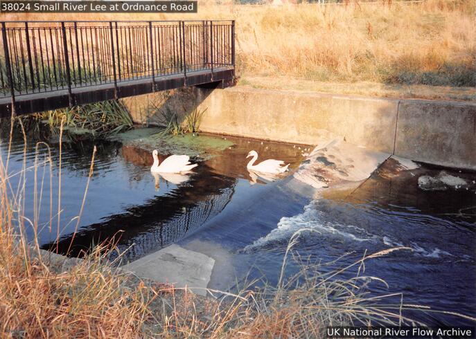
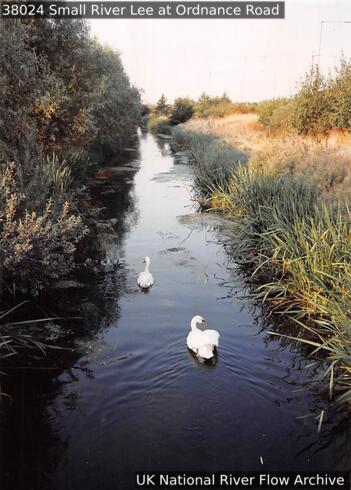
Photos

Gauging-station photographs from the National River Flow Archive (UKCEH).

Photos © NRFA / UKCEH & the measuring authority — shown at web resolution. Full gallery on the NRFA ↗

About this gauge

Station located in the lower reaches of the River Lee catchment.

More detail

The catchment

A predominantly impervious (clay), catchment with substantial superficial cover. Suburban in the valley, rural headwaters with considerable woodland.

The station

Flat V weir (1:10 cross-slope), 8m wide. Crest tapping does not operate effectively.

Flow regime

Responsive regime. Minor impact of artificial influences on flows, low discharges affected by gravel workings and pumped drainage from the M25 can be important.

The flow record

Subject to drowning.

Descriptions from the National River Flow Archive (UKCEH). NRFA station record ↗

Gauge Details

How this gauging station is built and how long it has measured (NRFA / UKCEH).

Gauge type
Flat-V weir
Operating since
1973
Station datum
15.3 mAOD
Flow record
1973–2024 · 51 yrs · 100% complete
Hydrometric area
38
Measured by
Environment Agency

Frequently asked questions

Is the Small River Lee at Enfield, Ordance Road flooding today?

The current level is 0.12m, which is within the typical range of 0.11 to 1.40m. Flooding is unlikely at this level.

Is the river level rising or falling at Enfield, Ordance Road?

Based on the most recent readings, the level is currently falling slightly. The chart above shows the last 12 hours of measurements by default (up to 7 days), updated roughly every 15 minutes.

What is a normal level for the Small River Lee at Enfield, Ordance Road?

The typical range at this station is 0.11m to 1.40m, based on Environment Agency historical data. Levels above 1.40m are higher than usually seen and may indicate a flood risk.

How often is this river level data updated?

Readings are supplied by the Environment Agency gauge. FloodRadar checks for updates roughly every 15 minutes; the timestamp above shows how recent the latest available reading is.

Embed this gauge on your website

Free live river-level widget — ideal for parish councils, angling clubs and local sites. Updates automatically.

Preview

📮 Flood risk by postcode near this gauge

Postcodes within 5 km with properties in the Environment Agency’s rivers-and-sea flood-risk bands:

Check any UK postcode’s flood risk →

🏠 Buying or renting around here? Get the Property Flood-Risk Report for any English postcode — official risk band, recorded floods, warning history, river behaviour and nearby storm overflows. £19 one-off. Learn more →